Apple Event: May 7th at 7 am PT

Apple Maps satellite images different on the web and in App. Why?

Hi,


I noticed Apple Maps on the web has quite new satellite images (Prague, Czechia) while the satellite images in the Maps App on Mac or iPhone are about 9 years old.

Does anybody noticed the same or know why would that be?


Thanks

MacBook Air (M1, 2020)

Posted on May 5, 2023 7:08 AM

Reply
Question marked as Best reply

Posted on May 5, 2023 10:44 AM

Lost my 15 minute edit window...


I'm not disputing that you see no difference in two specific images. But at a different level of detail, on a different network, connected to a different CDN region, possibly on a different platform, web browser, etc., all bets are off.


Edit: Here's a good example.

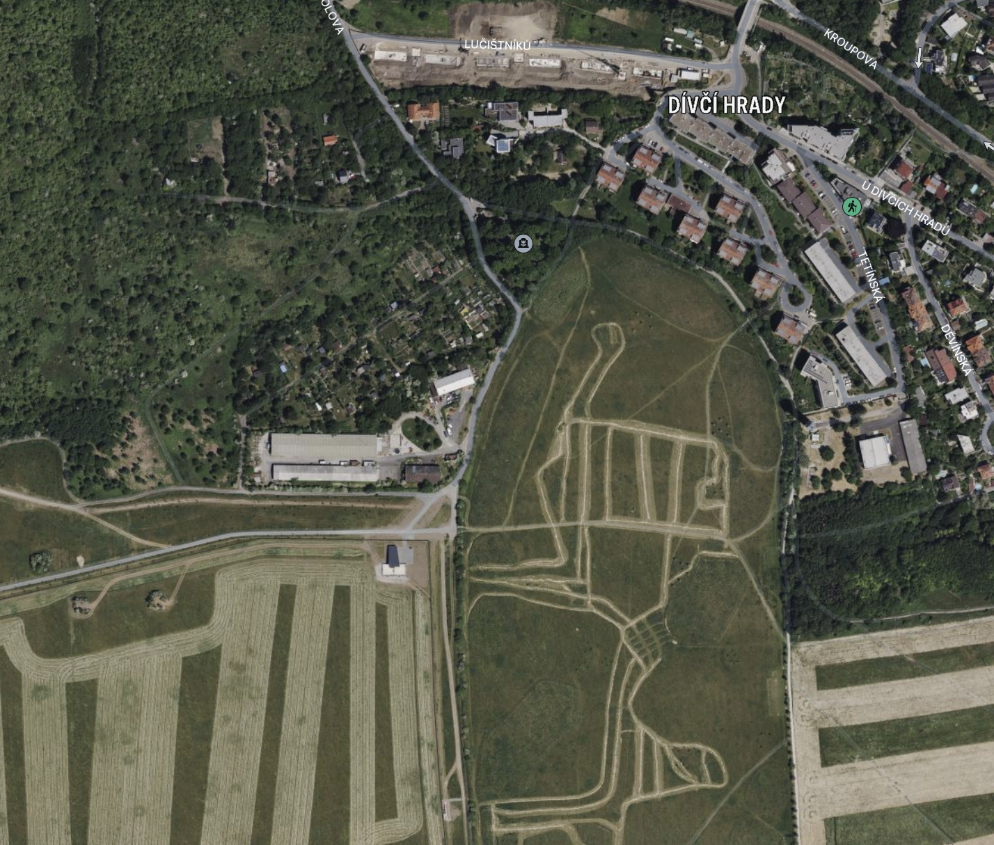
DuckDuckGo, using Apple Maps, in Safari on Monterey, from Canada looking at the outskirts of Prague:

Same location, using Apple Maps, the App, on Monterey, from Canada:
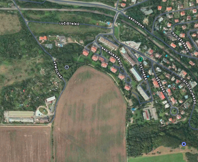

I don't know which of these is more current. They might both be current. These could be farm fields where one just happened to be in the middle of harvest that day. But they are most definitely different imagery.


Actually, I see a new building in the web version, so that's definitely newer by at least the time it takes to build a new building.


And maybe I have another category - Apple is its own worst enemy.


As I zoom way in using Apple Maps, I eventually get to a 3D view of this scene. Look's nice too. I now know it's old data, but 3D! Cool! But if I zoom back out, eventually I get a lower-resolution version that looks more like the web version. (Due to my farm field theory, I can't confirm it is newer.)


But my point is, I think Apple is making a point to use imagery that matches its 3D views, even if that is older. They don't seem to mind the significant changes in imagery at a lower level of detail. But once you get low enough to where you could compare with 3D, Apple is going to use data that matches the 3D data. Since that super-high resolution 3D data is much more difficult to get, that means that Apple's moderately-high resolution data is probably always going to be older than it would be on the web, where there is no 3D view.

16 replies
Question marked as Best reply

May 5, 2023 10:44 AM in response to dialabrain

Lost my 15 minute edit window...


I'm not disputing that you see no difference in two specific images. But at a different level of detail, on a different network, connected to a different CDN region, possibly on a different platform, web browser, etc., all bets are off.


Edit: Here's a good example.

DuckDuckGo, using Apple Maps, in Safari on Monterey, from Canada looking at the outskirts of Prague:


Same location, using Apple Maps, the App, on Monterey, from Canada:


I don't know which of these is more current. They might both be current. These could be farm fields where one just happened to be in the middle of harvest that day. But they are most definitely different imagery.


Actually, I see a new building in the web version, so that's definitely newer by at least the time it takes to build a new building.


And maybe I have another category - Apple is its own worst enemy.


As I zoom way in using Apple Maps, I eventually get to a 3D view of this scene. Look's nice too. I now know it's old data, but 3D! Cool! But if I zoom back out, eventually I get a lower-resolution version that looks more like the web version. (Due to my farm field theory, I can't confirm it is newer.)


But my point is, I think Apple is making a point to use imagery that matches its 3D views, even if that is older. They don't seem to mind the significant changes in imagery at a lower level of detail. But once you get low enough to where you could compare with 3D, Apple is going to use data that matches the 3D data. Since that super-high resolution 3D data is much more difficult to get, that means that Apple's moderately-high resolution data is probably always going to be older than it would be on the web, where there is no 3D view.

Nov 29, 2023 11:36 AM in response to milan260

I have no idea why Apple does this either, but it seems really short-sighted if they're only doing it to preserve the 3D transition, at the expense of up-to-date information.


For example, earlier this year I flew into O'hare International Terminal 5. When I looked on Maps on my iPhone, the gate was floating out in the middle of the tarmac. Little did I know that an expansion of the terminal had occurred. I had to check on Google Maps to understand what had happened.


O'Hare Terminal 5 (Satellite View on Maps.app on Sonoma)


I never knew that Apple has an updated satellite view:


O'Hare Terminal 5 (Satellite View using DuckDuckGo on Edge on Windows 11, Parallels)


What bugs me the most is that Apple is even holding back current information with the views that they have complete control over (Explore, Driving, Transit), showing us out-of-date information:


O'Hare Terminal 5 (Explore View on Maps.app on Sonoma)


I would rather have a bit of dissonance between the different views (Explore, Driving, Transit, Satellite, 3D) if at least one of the views had current information!


May 5, 2023 7:31 AM in response to milan260

milan260 wrote:

Does anybody noticed the same

No. Those satellite maps are useless with junk data.

know why would that be?

There could be many reasons. First of all, the data is junk. So there's that. People are generally only interested in looking at their house. So the data will get a lot better if you zoom in. But nobody cares about lower levels of detail. Or rather, the people who care about those lower levels of detail aren't using any Apple tools for their needs.


Secondly, this is a lot of data. An awful lot. Apple maintains global content distribution systems. Different interfaces may have access to different data that hasn't been globally distributed yet. Since Apple's web maps are practically unknown, they don't have much usage and can support more frequent updates.


And there could be licensing issues. Apple may have a web license for this specific set of data but not an app license. Or Apple could have an in-country license that is enforceable only via the web interface.


Or Apple's internal data-management could be a disaster with multiple, competing teams whose most sophisticated tool is Excel.

May 5, 2023 6:25 PM in response to dialabrain

dialabrain wrote:

I was just in Ventura exploring some Maps/Apple Maps/Google Maps differences.

One thing I noticed, Google Maps allows one to zoom in closer with more detail than Apple Maps or Apple Maps online.*

I don't know if Apple will ever be able to catch up to Google in terms of raw mapping data. I definitely prefer Apple's products and services from a utility and aesthetic point of view. But there is a while different side of Google (Google Earth Engine) that Apple just doesn't have. I'm not necessarily a fan of Google's approach, but they do have an unbelievable amount of data. Our tax dollars at work - for Google.

May 9, 2023 12:52 AM in response to milan260

Thank you very much for answers.

I was asking because I use Apple Maps often because it's faster and more convenient for me to use the App instead of a browser, but I was not satisfied with the (9 years) outdated images. Last week I noticed the web version has new images and I was wondering why is that.


I agree it's because of matching the 3D model with the images. The web version does not have the 3D feature so they can use the new images. But in the app it would look weird if it would suddenly change when going into 3D.

I hope they will update the 3D version soon or there should be a possibility to disable 3D and use the new images.


Why dialabrain has new images in the App is still a mystery to me. What would happen if you would zoom in and switch to 3D? Or maybe 3D disabled on in your app from some reason?

Nov 23, 2023 12:43 PM in response to milan260

Hey!


I love Apple Maps. I use it for a lot of things such as directions, exploring and area, and presentations. Thing about that last one though is that here in San Antonio TX, our 3D satellite image is from a little over 6 years ago!

If you live here you know that there has been a TON of construction in the past few years, especially up north. It’s also very small. The circumference is about <30 miles at its largest. Even the 2D view around the 3D is 3 years old. Just want to bring some attention to this. Not just us either. It’s also Austin and Amarillo.

Apple Maps satellite images different on the web and in App. Why?

Welcome to Apple Support Community
A forum where Apple customers help each other with their products. Get started with your Apple ID.