Want to highlight a helpful answer? Upvote!

Did someone help you, or did an answer or User Tip resolve your issue? Upvote by selecting the upvote arrow. Your feedback helps others! Learn more about when to upvote >

Looks like no one’s replied in a while. To start the conversation again, simply ask a new question.

GPS data in photos after exporting

Is there a way to access or check gps data in my photos after exporting to my desktop. I have to export photos to a local folder in order to import them into Lightroom Classic and I'm finding a lot of the gps data missing when it gets to Lightroom. Thanks.

MacBook Pro with Touch Bar

Posted on Feb 16, 2021 9:01 AM

Reply
Question marked as Best reply

Posted on Feb 16, 2021 10:13 AM

Open the images with Preview and bring up the Inspector/GPS pane. That will let you see if the image has any GPS data with it. If you have a folder with multiple image files in it and open the folder with Preview all the images should open in one PDF window so you can scroll thru them.


Similar questions

3 replies
Question marked as Best reply

Feb 16, 2021 10:13 AM in response to Rico75

Open the images with Preview and bring up the Inspector/GPS pane. That will let you see if the image has any GPS data with it. If you have a folder with multiple image files in it and open the folder with Preview all the images should open in one PDF window so you can scroll thru them.


Feb 16, 2021 10:43 AM in response to Rico75

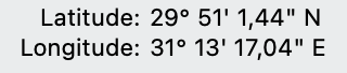
In Big Sur Finder > Get Info:


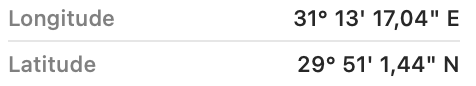
Finder window Column or Gallery view:


exiftool in degrees:


exiftool -a -G1 -s -ee '-*GPS*' 1967-1019-1200-09.jpg 
[GPS]           GPSVersionID                    : 2.3.0.0
[GPS]           GPSLatitudeRef                  : North
[GPS]           GPSLatitude                     : 29 deg 51' 1.44"
[GPS]           GPSLongitudeRef                 : East
[GPS]           GPSLongitude                    : 31 deg 13' 17.04"
[Composite]     GPSLatitude                     : 29 deg 51' 1.44" N
[Composite]     GPSLongitude                    : 31 deg 13' 17.04" E
[Composite]     GPSPosition                     : 29 deg 51' 1.44" N, 31 deg 13' 17.04" E


exiftool in decimals (I prefer this because Google Maps readily accepts '29.8504 31.2214' for paste):


exiftool -a -G1 -s -n -ee '-*GPS*' 1967-1019-1200-09.jpg 
[GPS]           GPSVersionID                    : 2 3 0 0
[GPS]           GPSLatitudeRef                  : N
[GPS]           GPSLatitude                     : 29.8504
[GPS]           GPSLongitudeRef                 : E
[GPS]           GPSLongitude                    : 31.2214
[Composite]     GPSLatitude                     : 29.8504
[Composite]     GPSLongitude                    : 31.2214
[Composite]     GPSPosition                     : 29.8504 31.2214


p.s. Notice that Big Sur Photos XMP sidecar has an export error in western and southern locations:


https://discussions.apple.com/thread/252258329

Feb 16, 2021 10:34 AM in response to Old Toad

Thank you for your help. I have also figured out that there is a switch in the Export settings to include location information. It was checked on, but there could have been a period when it was unchecked I guess and I wasn't getting gps data in my exports. Thanks again for your help. I learn a little more each day.

GPS data in photos after exporting

Welcome to Apple Support Community
A forum where Apple customers help each other with their products. Get started with your Apple ID.